The Hellenic Navy (HN) (Greek: Πολεμικό Ναυτικό, Polemikó Naftikó, abbreviated ΠΝ) is the naval force of Greece, part of the Greek Armed Forces. The modern Greek navy has its roots in the naval forces of various Aegean Islands, which fought in the Greek War of Independence. During the periods of monarchy (1833–1924 and 1936–1973) it was known as the Royal Navy (Βασιλικόν Ναυτικόν, Vasilikón Naftikón, abbreviated ΒΝ).The total displacement of all the navy's vessels is approximately 150,000 tons.The motto of the Hellenic Navy is "Μέγα το της Θαλάσσης Κράτος" from Thucydides' account of Pericles' oration on the eve of the Peloponnesian War. This has been roughly translated as "Great is the country that controls the sea". The Hellenic Navy's emblem consists of an anchor in front of a crossed Christian cross and trident, with the cross symbolizing Greek Orthodoxy, and the trident symbolizing Poseidon, the god of the sea in Greek mythology. Pericles' words are written across the top of the emblem. "The navy, as it represents a necessary weapon for Greece, should only be created for war and aim to victory."...............The Hellenic Merchant Marine refers to the Merchant Marine of Greece, engaged in commerce and transportation of goods and services universally. It consists of the merchant vessels owned by Greek civilians, flying either the Greek flag or a flag of convenience. Greece is a maritime nation by tradition, as shipping is arguably the oldest form of occupation of the Greeks and a key element of Greek economic activity since the ancient times. Nowadays, Greece has the largest merchant fleet in the world, which is the second largest contributor to the national economy after tourism and forms the backbone of world shipping. The Greek fleet flies a variety of flags, however some Greek shipowners gradually return to Greece following the changes to the legislative framework governing their operations and the improvement of infrastructure.Blogger Tips and Tricks
This is a bilingual blog in English and / or Greek and you can translate any post to any language by pressing on the appropriate flag....Note that there is provided below a scrolling text with the 30 recent posts...Αυτό είναι ένα δίγλωσσο blog στα Αγγλικά η/και στα Ελληνικά και μπορείτε να μεταφράσετε οποιοδήποτε ποστ σε οποιαδήποτε γλώσσα κάνοντας κλικ στη σχετική σημαία. Σημειωτέον ότι παρακάτω παρέχεται και ένα κινούμενο κείμενο με τα 30 πρόσφατα ποστς....This is a bilingual blog in English and / or Greek and you can translate any post to any language by pressing on the appropriate flag....Note that there is provided below a scrolling text with the 30 recent posts...Αυτό είναι ένα δίγλωσσο blog στα Αγγλικά η/και στα Ελληνικά και μπορείτε να μεταφράσετε οποιοδήποτε ποστ σε οποιαδήποτε γλώσσα κάνοντας κλικ στη σχετική σημαία. Σημειωτέον ότι παρακάτω παρέχεται και ένα κινούμενο κείμενο με τα 30 πρόσφατα ποστς.........

Showing posts with label Environmental. Show all posts

Friday, November 14, 2014

Πρόκειται για κάποιου άλλου είδους αιλουροειδές..[ 4915 ]


Γαλλία: Δεν είναι τίγρης που ψάχνουν τελικά, αλλά κάτι άλλο

Σύμφωνα με ειδικούς πρόκειται για κάποιο αιλουροειδές άλλου είδους
Γαλλία: Δεν είναι τίγρης που ψάχνουν τελικά, αλλά κάτι άλλο
Σύμφωνα με ειδικούς τα αποτυπώματα της "τίγρης" ανήκουν σε κάποιο άλλο είδους αιλουροειδούς. ( Πηγή: AP Photo/Thibault Camus)

Το ζώο για το οποίο έχει στηθεί μια τεράστια επιχείρηση για τον εντοπισμό του, κοντά στο Παρίσι, δεν είναι τίγρη αλλά κάποιο αιλουροειδές άλλου είδους, ανακοίνωσαν την Παρασκευή οι αρχές, αφού ανέλυσαν τα αποτυπώματά του.
«Η παρουσία μιας τίγρης έχει πλέον αποκλειστεί» ανέφερε η νομαρχία επικαλούμενη τα συμπεράσματα των ειδικών του γαλλικού οργανισμού για την άγρια ζωή. «Το αιλουροειδές (...) αναζητείται ακόμη», προστίθεται στην ανακοίνωση.

Η επιχείρηση από αστυνομικούς, χωροφύλακες και περίπου δέκα στρατιώτες επαναλήφθηκε στις 08.00 το πρωί σε μια περιοχή ερευνών που αντιστοιχεί σε τέσσερα με πέντε γήπεδα ποδοσφαίρου στο Μοντεβρέν, 40 χλμ. ανατολικά του Παρισιού.
Ελικόπτερο εξοπλισμένο με θερμική κάμερα συνεχίζει να περιστρέφεται πάνω από την περιοχή αυτή.

«Το ελικόπτερο έκανε πτήσεις τη νύχτα, αλλά οι έρευνες δεν έχουν ακόμη δώσει κανένα αποτέλεσμα. Ακόμα τίποτα για το πού μπορεί να βρίσκεται η τίγρη», δήλωσε πηγή της νομαρχίας.

Όπως χθες, έχουν δοθεί οδηγίες στους κατοίκους της Μοντεβρέν, εκεί όπου εθεάθη το αιλουροειδές χθες, αλλά και στις γύρω κοινότητες Σεσί και Σαλιφέρ να μετακινούνται με αυτοκίνητο και να αποφεύγουν δασώδεις περιοχές.

Δυνάμεις της αστυνομίας αναπτύχθηκαν γύρω από σχολεία πριν από την έναρξη των μαθημάτων, δήλωσε η πηγή της νομαρχίας.

Στις έρευνες, που είχαν διακοπεί τη χθεσινή νύχτα, μετείχαν περισσότεροι από εκατό άνδρες: αστυνομικοί, πυροσβέστες, ειδικές ομάδες, ακόμη και σκυλί Καρελίας, ειδικό για το κυνήγι της αρκούδας και μεγάλων θηραμάτων.

Το αιλουροειδές εθεάθη χθες το πρωί από τη σύζυγο του διευθυντή ενός σούπερ μάρκετ στο Μοντεβρέν, η οποία φωτογράφισε το άγριο ζώο και ειδοποίησε τις αρχές. Τενίστες ανέφεραν επίσης ότι είδαν το ζώο, σύμφωνα με πηγή προσκείμενη στην έρευνα.

Οι αρχές και οι ειδικοί που παρενέβησαν χθες είναι κατηγορηματικοί: οι φωτογραφίες και οι αναλύσεις των αποτυπωμάτων επιβεβαιώνουν ότι πράγματι πρόκειται για τίγρη. Στο παρελθόν παρόμοιες κλήσεις στην αστυνομία κατέληγαν τελικά στο συμπέρασμα ότι επρόκειτο για μεγάλη γάτα.

Friday, May 2, 2014

North Sea 'Atlantis' [ 4130 ]

Prehistoric North Sea 'Atlantis' hit by 5m tsunami


Map
A prehistoric "Atlantis" in the North Sea may have been abandoned after being hit by a 5m tsunami 8,200 years ago.
The wave was generated by a catastrophic subsea landslide off the coast of Norway.
Analysis suggests the tsunami over-ran Doggerland, a low-lying landmass that has since vanished beneath the waves.
"It was abandoned by Mesolithic tribes about 8,000 years ago, which is when the Storegga slide happened," said Dr Jon Hill from Imperial College London.


“Start Quote

The impact... would have been massive - comparable to the Japanese tsunami of 2011”
Dr Jon Hill Imperial College London
 
The wave could have wiped out the last people to occupy this island.
The research has been submitted to the journal Ocean Modelling and is being presented at the European Geosciences Union General Assembly in Vienna this week.
Dr Hill and his Imperial-based colleagues Gareth Collins, Alexandros Avdis, Stephan Kramer and Matthew Piggott used computer simulations to explore the likely effects of the Norwegian landslide.
He told BBC News: "We were the first ever group to model the Storegga tsunami with Doggerland in place. Previous studies have used the modern bathymetry (ocean depth)."
As such, the study gives the most detailed insight yet into the likely impacts of the huge landslip and its associated tsunami wave on this lost landmass.
This animation shows the evolution of the wave - the red shows the height and the blue colour the depth of variation in the sea surface
During the last Ice Age, sea levels were much lower; at its maximum extent Doggerland connected Britain to mainland Europe.

“Start Quote

I think they are probably right, because the tsunami would have been a catastrophic event”
Prof Vince Gaffney University of Birmingham
It was possible for human hunters to walk from what is now northern Germany across to East Anglia.
But from 20,000 years ago, sea levels began to rise, gradually flooding the vast landscape.
By around 10,000 years ago, the area would still have been one of the richest areas for hunting, fishing and fowling (bird catching) in Europe.
A large freshwater basin occupied the centre of Doggerland, fed by the River Thames from the west and by the Rhine in the east. Its lagoons, marshes and mudflats would have been a haven for wildlife.
"In Mesolithic times, this was paradise," explained Bernhard Weninger, from the University of Cologne in Germany, who was not involved with the present study.
But 2,000 years later, Doggerland had become a low-lying, marshy island covering an area about the size of Wales.
Spears The North Sea has given up wonderful prehistoric finds, like these bone points now kept at the National Museum of Antiquities in Leiden, The Netherlands
This shaft-hole pick made from antler was found near Rotterdam in the Netherlands This shaft-hole pick made from antler was found near Rotterdam in the Netherlands
Last year, National Museum of Antiquities curator Luc Amkreutz identified this flint tool as a Mesolithic tranchet axe - the first such find from the North Sea. It was found by a Dutch fisherman in 1988 Last year, National Museum of Antiquities curator Luc Amkreutz identified this flint tool as a Mesolithic tranchet axe - the first such find from the North Sea. It was found by a Dutch fisherman in 1988
The nets of North Sea fishing boats have pulled up a wealth of prehistoric bones belonging to the animals that once roamed this prehistoric "Garden of Eden".
But the waters have also given up a smaller cache of ancient human remains and artefacts from which scientists have been able to obtain radiocarbon dates.
And they show that none of these relics of Mesolithic habitation on Doggerland occur later than the time of the tsunami.
The Storegga slide involved the collapse of some 3,000 cubic km of sediment.
"If you took that sediment and laid it over Scotland, it would cover it to a depth of 8m," said Dr Hill.
Given that the majority of Doggerland was by this time less than 5m in height, it would have experienced widespread flooding.
These young Mesolithic women from Teviec, Brittany, were brutally murdered. As sea levels rose competition for resources may have intensified These young Mesolithic women from Teviec, Brittany, were brutally murdered. As sea levels rose competition for resources may have intensified
"It is therefore plausible that the Storegga slide was indeed the cause of the abandonment of Doggerland in the Mesolithic," the team writes in their Ocean Modelling paper.
Dr Hill told BBC News: "The impact on anyone who was living on Doggerland at the time would have been massive - comparable to the Japanese tsunami of 2011."
But Bernhard Weninger suspects that Doggerland had already been vacated by the time of the Storegga slide.
"There may have been a few people coming with boats to fish, but I doubt it was continuously settled," he explained.
"I think it was so wet by this time that the good days of Doggerland were already gone."
Prof Vince Gaffney, an archaeologist at the University of Birmingham, said: "I think they (the researchers) are probably right, because the tsunami would have been a catastrophic event."
But he stressed that the archaeological record was sparse, and explained that two axes from the Neolithic period (after Storegga) had been retrieved from the North Sea's Brown Banks area.
It is possible these were dropped from a boat - accidentally or as a ritual offering - but it is also unclear precisely when Doggerland finally succumbed to the waves.
The ancient landmass of Doggerland took several thousand years to flood
"Even after major volcanic eruptions, people go back, sometimes because they can't afford not to but also because the resources are there," said Prof Gaffney, who has authored a book, Europe's Lost World: The Rediscovery of Doggerland.
The tsunami would also have affected what is now Scotland and the eastern coast of England, as well as the northern coast of continental Europe.
The wave that hit the north-east coast of Scotland is estimated to have been some 14m high, though it is unclear whether this area was inhabited at the time.
But waves measuring some 5m in height would have hit the eastern coast of England, and there is good evidence humans were in this area 8,000 years ago.
Much of this region would also have been low-lying, suggesting the impact on Mesolithic people who depended substantially on coastal resources such as shellfish, would have been significant here, too.-

Wednesday, April 30, 2014

USA, Powerful spring storm system..[ 4123 ]

Deadly storm claims 35 lives

CNN|Added on April 29, 2014 
The first two days of a powerful spring storm system has over 75 million Americans under threat.
.
VIDEO,  please enlarge screen 
.

Σεισμός 4,8 Ρίχτερ βορείως της Ανδρου..[ 4116 ]


Σεισμός 4,8 Ρίχτερ βορείως της Ανδρου

iKathimerini.gr // 30 Απριλίου 2014

Σεισμική δόνηση μεγέθος 4,8 της κλίμακας Ρίχτερ σημειώθηκε λίγο μετά τις επτά το πρωί της Τετάρτης, στον θαλάσσιο χώρο βορείως της Ανδρου.

Σύμφωνα με τις πρώτες πληροφορίες του Γεωδυναμικού Ινστιτούτου του Εθνικού Αστεροσκοπείου, το επίκεντρο του σεισμού ήταν 47.2 χιλιόμετρα βορειοανατολικά της Ανδρου και το εστιακό βάθος ήταν 10 χιλιόμετρα.

Η σεισμική δόνηση σημειώθηκε στις 07:03 και έγινε αισθητή μέχρι και την Αθήνα. Ακολούθησαν μετασεισμοί μεγέθους 2,8 και 3,2 βαθμών με το ίδιο επίκεντρο.

Tuesday, April 29, 2014

Στους 17 οι νεκροί των ανεμοστρόβιλων στις ΗΠΑ..[ 4113 ]

Στους 17 οι νεκροί των ανεμοστρόβιλων στις ΗΠΑ σε Άρκανσο και Οκλαχόμα
  Τόνια Γιαννιώτη // Ναυτεμπορική // 28/04/2014 - 16:54

Οι ανεμοστρόβιλοι που έπληξαν τις νότιες και νοτιο-δυτικές πολιτείες των ΗΠΑ προκάλεσαν τον θάνατο τουλάχιστον 17 ανθρώπων, ανακοίνωσαν οι αρχές της Οκλαχόμα και του Άρκανσο.

Οι υπηρεσίες αντιμετώπισης εκτάκτων καταστάσεων ανακοίνωσαν ότι τουλάχιστον 10 άνθρωποι σκοτώθηκαν στην κομητεία Φόκνερ του κεντρικού Άρκανσο, έξι στην υπόλοιπη πολιτεία και ένας στη γειτονική Οκλαχόμα.

Δέντρα ξεριζώθηκαν, αυτοκίνητα ανατράπηκαν και οι σκεπές σπιτιών αποκολλήθηκαν σε πολλές περιοχές, αναφέρουν τα μέσα ενημέρωσης.

Το δορυφορικό δίκτυο Weather Channel μετέδωσε πλάνα με αναποδογυρισμένα αυτοκίνητα μέσα στα οποία είχαν εγκλωβιστεί οι οδηγοί και οι επιβάτες τους και τα οποία σχημάτιζαν ουρές 35 χιλιομέτρων βορειοδυτικά της πρωτεύουσας του Άρκανσο, του Λιτλ Ροκ.Πρόκειται για τις σφοδρότερες καταιγίδες και ανεμοστρόβιλους στις ΗΠΑ για το 2014.

Η Εθνική Μετεωρολογική Υπηρεσία προέβλεψε και νέους ανεμοστρόβιλους και ισχυρές καταιγίδες σε πολλά τμήματα του Άρκανσο, στην ανατολική Οκλαχόμα, στο βορειοανατολικό Τέξας και στο νότιο Μισούρι.

Στους 17 οι νεκροί των ανεμοστρόβιλων στις ΗΠΑ

Σε Άρκανσο και Οκλαχόμα
tornado
A+ α-


28/04/2014 - 16:54
Οι ανεμοστρόβιλοι που έπληξαν τις νότιες και νοτιο-δυτικές πολιτείες των ΗΠΑ προκάλεσαν τον θάνατο τουλάχιστον 17 ανθρώπων, ανακοίνωσαν οι αρχές της Οκλαχόμα και του Άρκανσο.
Οι υπηρεσίες αντιμετώπισης εκτάκτων καταστάσεων ανακοίνωσαν ότι τουλάχιστον 10 άνθρωποι σκοτώθηκαν στην κομητεία Φόκνερ του κεντρικού Άρκανσο, έξι στην υπόλοιπη πολιτεία και ένας στη γειτονική Οκλαχόμα.
Δέντρα ξεριζώθηκαν, αυτοκίνητα ανατράπηκαν και οι σκεπές σπιτιών αποκολλήθηκαν σε πολλές περιοχές, αναφέρουν τα μέσα ενημέρωσης.
Το δορυφορικό δίκτυο Weather Channel μετέδωσε πλάνα με αναποδογυρισμένα αυτοκίνητα μέσα στα οποία είχαν εγκλωβιστεί οι οδηγοί και οι επιβάτες τους και τα οποία σχημάτιζαν ουρές 35 χιλιομέτρων βορειοδυτικά της πρωτεύουσας του Άρκανσο, του Λιτλ Ροκ.Πρόκειται για τις σφοδρότερες καταιγίδες και ανεμοστρόβιλους στις ΗΠΑ για το 2014.
Η Εθνική Μετεωρολογική Υπηρεσία προέβλεψε και νέους ανεμοστρόβιλους και ισχυρές καταιγίδες σε πολλά τμήματα του Άρκανσο, στην ανατολική Οκλαχόμα, στο βορειοανατολικό Τέξας και στο νότιο Μισούρι.
Ναυτεμπορική
- See more at: http://www.anexartiti.gr/news/world/16784/stous-17-i-nekri-ton-anemostrovilon-stis-ipa/#sthash.lpnIWoH5.dpuf

Monday, April 28, 2014

Tornado in Arkansas..[ 4112 ]

Tornado rips through Arkansas

CNN|Added on April 27, 2014

 CNN's Chad Myers is on the ground in Arkansas, where a tornado tore through the area, causing massive damage.
.
VIDEO, please enlarge screen 
..

Saturday, April 26, 2014

Iconic Santorini, Greece..[ 4096 ]

.Sneak Peek: Iconic Santorini, Greece
Jennifer Ashton Ryan

The Iconic Santorini cave hotel seemingly hangs over the rim of Greece’s famed volcanic caldera.

Why Go: Santorini wins travelers for its cliff-top views and whitewashed Cycladic architecture. Highlighting both is the new Iconic Santorini, a collection of 22 whitewashed rooms (from $540, including breakfast) that are literally carved from former cave homes and shops in the quiet village of Imerovigli. 


The hotel opens for the season in April with a restaurant, a small gym, and a spa. 

Blue-domed churches and charming shops in Imerovigli are an easy walk from neighboring Fira, yet are tucked away from Santorini’s cruise-ship crowds.
.
What to Expect: Terraces with inviting seating arrangements are prime vantages to take in the caldera views. The cave-style rooms, decorated with colorful pillows and exposed wooden beams, are set back from the rim. Guests should be comfortable navigating stairs and the quirks of a boutique hotel’s atmosphere. 

.
Upgrade to a suite for more space: Caldera Suites come with heated, jetted outdoor pools perched on the caldera rim; jetted pools in the Grotto Suites are indoors; the Cliff Suite has some of the best views; and the Iconic Suite offers the most square footage.
How to Get There:The hotel is a 15-minute drive from the Santorini airport. (+30.22860.28950,

Wednesday, April 23, 2014

'Ocean quack sound' solved..[ 4073 ]

Mystery of 'ocean quack sound' solved


Antarctic minke whale  
The bizarre noise was first heard 50 years ago but now scientists say the Antarctic minke whale is its source
The mystery of a bizarre quacking sound heard in the ocean has finally been solved, scientists report.
The noise - nicknamed "the bio-duck" - appears in the winter and spring in the Southern Ocean. However, its source has baffled researchers for decades.
.
Now acoustic recorders have revealed that the sound is in fact the underwater chatter of the Antarctic minke whale.
The findings are published in the Royal Society journal Biology Letters
.
Lead researcher Denise Risch, from the US National Oceanic and Atmospheric Administration (Noaa) Northeast Fisheries Science Center in Massachusetts, said: "It was hard to find the source of the signal.
"Over the years there have been several suggestions... but no-one was able to really show this species was producing the sound until now."
.
If it quacks like a duck
The strange sound was first detected by submarines about 50 years ago. Those who heard it were surprised by its quack-like qualities.


Antarctic Minke whale The researchers attached acoustic monitoring tags to the whales to eavesdrop on them
The researchers do not yet know under what circumstances the minke whales make their distinctive vocalisations, although the sounds that were recorded were produced close to the surface and before the mammals made deep dives to feed.
.
The team says solving this long-standing mystery will help them to learn more about these little-studied animals.
Dr Risch said: "Identifying their sounds will allow us to use passive acoustic monitoring to study this species. 
.
"That can give us the timing of their migration - the exact timing of when the animals appear in Antarctic waters and when they leave again - so we can learn about migratory patterns, about their relative abundance in different areas and their movement patterns between the areas."
.
The team will be analysing data from the PALAOA station, the Alfred Wegener Institute's (AWI) permanent acoustic recording station in Antarctica, which has been recording in the Southern Ocean continuously in the last few years.
.
This is not the only acoustic puzzle that scientists have recently shed light on
Another baffling low frequency noise - called The Bloop - turned out to be the sound of Antarctica's ice cracking.

Tuesday, April 22, 2014

Σημερα, η πρώτη βροχή διαττόντων ..[ 4065 ]

H πρώτη βροχή διαττόντων της άνοιξης


Η πρώτη βροχή διαττόντων αστέρων της άνοιξης, οι Λυρίδες, εμφανίστηκαν ήδη στον ουρανό του βορείου ημισφαιρίου, όπου ανήκει και η Ελλάδα.
Οι πτώσεις των συγκεκριμένων μετεώρων εμφανίζουν την αποκορύφωσή τους στο διήμερο 21 και 22 Απριλίου, ενώ θα είναι ορατές έως τις 25 του μηνός - εφόσον ο κατά τόπους καιρός επιτρέπει τις νυχτερινές παρατηρήσεις.

Στο αποκορύφωμα του φαινομένου εισέρχονται στη γήινη ατμόσφαιρα και πυρακτώνονται έως 20 «πεφταστέρια» ανά ώρα με ταχύτητα περίπου 50 χιλιομέτρων/ώρα.

Οι Λυρίδες μερικές φορές δημιουργούν πολύ φωτεινά πεφταστέρια με μακριές ουρές, ορατές στον ουρανό επί αρκετά δευτερόλεπτα.
Κάποιες χρονιές μάλιστα, τα μετέωρά τους έφθασαν μέχρι και τα 100 χλμ/ώρα, όπως μεταδίδει το Αθηναϊκό Πρακτορείο.

Η συγκεκριμένη βροχή μετεώρων, που καταγράφηκε για πρώτη φορά το 687 π.Χ. από τους Κινέζους, φαίνεται να προέρχεται από τον αστερισμό της Λύρας, από όπου πήρε το όνομά της, και ιδίως από τον αστέρα Βέγα (Άλφα Λύρας), ο οποίος είναι το πιο λαμπρό άστρο του συγκεκριμένου αστερισμού και το δεύτερο φωτεινότερο άστρο του νυχτερινού ουρανού του βορείου ημισφαιρίου.

Η πραγματική όμως πηγή προέλευσης είναι ο κομήτης «Θάτσερ», που ανακάλυψε το 1861 ο αμερικανός Α. Θάτσερ, ο οποίος αφήνει στο πέρασμά του μια μακριά ουρά σκόνης και σωματιδίων, που διασταυρώνεται κάθε χρόνο με την τροχιά του πλανήτη μας.

Ο κομήτης εκτιμάται ότι θα ξαναπεράσει πολύ κοντά από τη Γη το έτος 2276, καθώς η τροχιά του γύρω από τον Ήλιο διαρκεί περίπου 415 χρόνια.

Τα απομεινάρια από την ουρά του, μετά το τελευταίο κοντινό πέρασμά του τον 19ο αιώνα, αιωρούνται ακόμα στο διάστημα και συνεχίζουν κάθε χρόνο να προκαλούν τη «βροχή» των Λυρίδων. Ορισμένοι αστρονόμοι εκτιμούν ότι η επόμενη θεαματική βροχή Λυρίδων θα λάβει χώρα το 2040-41.

Mysterious object seen over Murmansk, Russia...[ 4063 ]

Meteor or UFO? Fireball lights up sky

CNN Newsroom|Added on April 19, 2014

 Russia Today says officials have not yet identified this mysterious object seen in the sky over Murmansk, Russia.
VIDEO: 


Friday, April 18, 2014

Ισχυρός σεισμός.στο Μεξικό...[ 4038 ]

7,5 Ρίχτερ «κούνησαν» το Μεξικό

Ηλεκτρονική Έκδοση enet.gr, 19:00 Παρασκευή 18 Απριλίου 2014

   
Το επίκεντρο στη Γκερέρο Σκηνές πανικού στους δρόμους.

.
Ισχυρός σεισμός έπληξε τη Μ. Παρασκευή το Μεξικό, σείοντας κτίρια στην πρωτεύουσα και στέλνοντας πανικόβλητους ανθρώπους στους δρόμους.
Ο σεισμός, μεγέθους 7,5 βαθμών, είχε επίκεντρο τη δυτική πολιτεία Γκερέρο, βόρεια του παραθαλάσσιου θέρετρου Ακαπούλκο, ανέφερε το Ινστιτούτο Γεωλογικής Επισκόπησης των Ηνωμένων Πολιτειών. Δεν υπάρχουν προς το παρόν πληροφορίες για μεγάλες υλικές ζημιές. 
---------------

Magnitude-7.2 earthquake shakes Mexican capital

Associated Press
.
Earthquake Rattles Mexico City
ACAPULCO, Mexico (AP) — A powerful magnitude-7.2 earthquake shook central and southern Mexico on Friday, sending panicked people into the streets, where broken windows and debris fell, but there were no early reports of major damage or casualties.

The U.S. Geological Survey said it was centered northwest of the Pacific resort of Acapulco, where many Mexicans are vacationing for the Easter holiday.
It was felt across at least a half-dozen states and Mexico's capital, where it shook for at least 30 seconds. Around the region, there were reports of isolated and minor damage, such as fallen fences, trees and broken windows. Chilpancingo, capital of the southern state of Guerrero, where the quake was centered, reported a power outage, but service was restored after 15 minutes.
In Acapulco, 59-year-old Enedina Ramirez Perez was having breakfast, enjoying the holiday with about 20 family members, when her hotel started to shake.
"People were turning over chairs in their desperation to get out, grabbing children, trampling people," the Mexico City woman said. "The hotel security was excellent and starting calming people down. They got everyone to leave quietly."
The quake struck 170 miles (273 kilometers) southwest of Mexico City, where people fled high rises and took to the streets, many in still in their bathrobes and pajamas on their day off.
"I started to hear the walls creak and I said, 'Let's go,'" said Rodolfo Duarte, 32, who fled his third-floor apartment.
"This is really strong," said Gabriel Alejandro Hernandez Chavez, 45, an apartment building guard in Mexico City. "And I'm accustomed to earthquakes."
The USGS initially calculated the quake's magnitude at 7.5, but later downgraded it to 7.2. It said the quake was centered 22 miles (36 kilometers) northwest of the town of Tecpan de Galeana, and was 15 miles (24 kilometers) deep.
In many cases of earthquakes in Mexico, it can take time to receive word from remote areas near the epicenter, where damage could be more extensive. No one answered the phone at the city hall for Tecpan de Galeana.
Mexico City itself is vulnerable even to distant earthquakes because much of it sits atop the muddy sediments of drained lake beds that quiver as quake waves hit.
The magnitude-8.1 quake in 1985 that killed at least 6,000 people and destroyed many buildings in Mexico City was centered 250 miles (400 kilometers) away on the Pacific Coast.
 

Chinese lining up to breathe fresh air via sealed bags...[ 4034 ]

Chinese residents line up for bags of fresh mountain air

By Frances Cha and Hiufu Wong, CNN
Posted 18/4/2014..,,edited April 4, 2014 -- Updated 0602 GMT (1402 HKT)
Photographs of residents of Zhengzhou, the capital of China's Henan Province, lining up for a chance to breathe fresh mountain air via sealed bags.

(CNN) -- Whatever the motive behind the event, it made for some powerful images of some China residents' desperation for better air.
Making the media rounds this week are photographs of residents of Zhengzhou, the capital of China's Henan Province, lining up for a chance to breathe fresh mountain air via sealed bags.
Some of the more heart-tugging photos were of parents and grandparents fixing the masks on children's faces so they can have a few rare sniffs of the fresh O2.
Zhengzhou is one of China's worst cities for air pollution, ranking 10th in a Greenpeace list of the country's most polluted cities in 2013, which used official data from the Ministry of Environmental Protection.
At the time of writing, Zhengzhou's AQI (Air Quality Index) recorded an "unhealthy" 157. Even Beijing, often the subject of bad pollution headlines, recorded a "moderate" AQI of 55 (the capital made headlines with its off-the-chart AQI reading of 755 last January).
Zhengzhou is one of the worst cities in China for air pollution.

The late-March series of events were part clever travel marketing gimmick, part public awareness campaign for China's air pollution crisis, put on by Laojun Mountain Natural Reserve Development Co.
The company brought in 2,000 cans and 40 bags of air that had been packed in Laojun Mountain, also located in Henan Province.
"A TV crew came to Laojun Mountain to test the air and found it unbelievably good and we had the idea of doing this to promote tourism to the area," sales and marketing officer for the park Khurram Zhang told CNN.
Known for its fresh air, the mountain was designated a national nature reserve in 1997, and sits 120 kilometers away from the nearest city of Luoyang.
"We collected 2,000 cans of air from She Shen Ya (a cliff on Laojun Mountain) early last month and we gave them out in multiple locations as a marketing campaign. It was gone in 20 minutes," said Zhang.
"We've launched two more events giving away air from the mountain. There will be more free fresh air coming in the fut

Thursday, April 17, 2014

Grand Canyon View ..[ 4024 ]

  Grand Canyon Geology Lessons on View 
.
Astronaut photograph (ISS039-E-5258) of the Grand Canyon, taken on March 25, 2014 by the Expedition 39 crew aboard the International Space Station.

Grand Canyon Geology Lessons on View
The Grand Canyon in northern Arizona is a favorite for astronauts shooting photos from the International Space Station, as well as one of the best-known tourist attractions in the world. The steep walls of the Colorado River canyon and its many side canyons make an intricate landscape that contrasts with the dark green, forested plateau to the north and south.
.
The Colorado River has done all the erosional work of carving away cubic kilometers of rock in a geologically short period of time. Visible as a darker line snaking along the bottom of the canyon, the river lies at an altitude of 715 meters (2,345 feet), thousands of meters below the North and South Rims. 
.
Temperatures are furnace-like on the river banks in the summer. But Grand Canyon Village, the classic outlook point for visitors, enjoys a milder climate at an altitude of 2,100 meters (6,890 feet).
The Grand Canyon has become a geologic icon—a place where you can almost sense the invisible tectonic forces within the Earth. The North and South Rims are part of the Kaibab Plateau, a gentle tectonic swell in the landscape. 
.
The uplift of the plateau had two pronounced effects on the landscape that show up in this image. First, in drier parts of the world, forests usually indicate higher places; higher altitudes are cooler and wetter, conditions that allow trees to grow. 
.
The other geologic lesson on view is the canyon itself. Geologists now know that a river can cut a canyon only if the Earth surface rises vertically. If such uplift is not rapid, a river can maintain its course by eroding huge quantities of rock and forming a canyon.
.
This astronaut photograph (ISS039-E-5258) was taken on March 25, 2014 by the Expedition 39 crew, with a Nikon D3S digital camera using a 180 millimeter lens, and is provided by the ISS Crew Earth Observations Facility and the Earth Science and Remote Sensing Unit, Johnson Space Center. It has been cropped and enhanced to improve contrast, and lens artifacts have been removed.
> View annotated image
Image Credit: NASA
Caption: M. Justin Wilkinson, Jacobs at NASA-JSC

Sunday, April 13, 2014

Second quake hit Solomon Islands ...[ 3996 ]


Solomon Islands hit by second quake


Map locator
A magnitude 7.5 earthquake has struck off the Solomon Islands - less than a day after a similar strength tremor.
A tsunami warning was in effect in the Solomon Islands, Vanuatu and Papua New Guinea, although it was not known whether a tsunami had been generated.
The latest quake was registered at a depth of 20km (12 miles) below the seabed, the US Geological Survey said.
There were no reports of major damage or casualties after the first quake early Sunday local time.
That tremor woke people in the Solomon Islands, striking at 07:14 local time (20:14 GMT), and was followed by a 5.9 magnitude aftershock.
Houses falling into a swollen river in the Solomon Islands 6 April 2014  
 .
The Solomon Islands were only recently hit by severe flooding
The Pacific Tsunami Warning Centre reported indications of a small tsunami which may have caused some damage hear the epicentre 323km (200 miles) southeast of the capital, Honiara.
The Solomon Islands lies in a zone prone to frequent earthquakes and volcanic activity.
In February, several people were killed after a tsunami triggered by a magnitude 8.0 quake struck near the Santa Cruz islands - part of the Solomon Islands nation.
The latest quakes come only a week after the Solomon Islands were hit by severe flooding, which left more than 20 people dead.

Landslide on Penarth beach ..[ 3994 ]

No-one hurt in 30-tonnes landslide on Penarth beach 

BBC., 

Landslide at Penarth  
.
Crews were working to make the area safe before people are allowed on to the beach
Emergency services are dealing with a large landslide on to a beach in the Vale of Glamorgan.
.
South Wales Fire and Rescue Service say 30 tonnes of the cliff face near Penarth pier has come away, but there are no reports of anyone being trapped.
.
The area is currently being made safe and work is being carried out to try to prevent any further collapse.
People are asked to avoid the area until further notice.

Wyoming : slow-moving landslide, evacuate residents...[ 3991 ]

Wyoming officials eye slow-moving landslide, evacuate residents

By Michael Martinez, CNN
April 13, 2014 -- Updated 0229 GMT (1029 HKT)
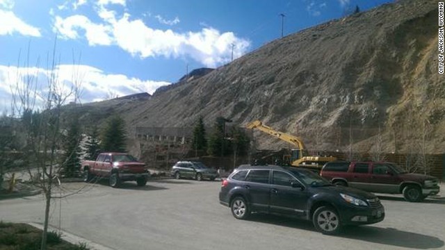
The 100-foot-deep landslide is moving so slowly that local officials have been able to see how ground cracks are emerging and growing by inches each day.

(CNN) -- A slow-moving landslide the size of two football fields is steadily tearing apart a hilltop house from the inside and has prompted the evacuation of about 50 people and several businesses in the well-known skiing town of Jackson, Wyoming, officials said Saturday.
The slow movement, however, has only a 5% chance of becoming the sort of violent landslide that killed 36 people last month in rural Washington state, said Roxanne Robinson, Jackson assistant town manager.
"You know, I think that's on everybody's mind, but I think our slide is different because it's slow moving. Theirs was catastrophic, and ours has been slowly creeping down the hill," Robinson said Saturday.
.
The 100-foot-deep landslide is moving so slowly that local officials have been able to see how ground cracks are emerging and growing by inches each day the past week. Crews use binoculars to keep an eye on the hill while they stand at a fire truck across the road.
A mandatory evacuation order issued Thursday to 46 residential units in the landslide zone remained in place Saturday.
Authorities count about 57 residents in the landslide area, but only 48 people have reported to a Red Cross check-in station, Robinson said. The remainder are still residing in their homes or may be away from home, she said.
"There are people living there who have refused to leave. That's their choice because we can't forcibly remove them," Robinson said. "On one side of the (hillside) road, we did have a sinkhole develop, and it's not safe to dig it out and put a man in the hole.
.
On Saturday, about 43 people were escorted to their homes to remove personal items and check on the security of their belongings, according to a press release from the town of Jackson.
Emergency personnel will continue to escort residents to their home Sunday. Starting Monday, escorts back to residences will be by appointment only, according to the press release.
.
Red Cross personnel trained a dozen local people Saturday to staff a public shelter they plan to open Sunday evening.
For now, officials are doing testing extending 100 feet underground to determine how big of a threat the slide is and what they can do to limit its impact, Robinson said. The town has hired a geologist to examine the matter.
At a minimum, a house atop a hill is unlikely to be inhabitable again because its interior wooden floor is splitting into two, Robinson said. The driveway is cracked by a 6- to 12-inch upward fissure in the ground, she added.
"What really struck me is the wood flooring, which is separating," she said. "One half of the house looks like it's on side of the slide area and the other half is definitely at the crest of the slide.
.
"We did a media tour yesterday," she said Saturday, "and after we did that, the geologist said, 'You can't do that anymore. It's dangerous.'"
The slow landslide began March 4 when the event moved a town water pumphouse and broke a 16-inch water main, sending water gushing into a two-lane highway, Robinson said.
.
The landslide is occurring about a mile west of the town center, on a stretch of highway that's home to a Walgreens that opened with the new year, two restaurants and a liquor store -- all of which are closed for now, Robinson said.
The broken water main forced local officials to lay a two-inch water line up the steep hill's surface to connect to 46 residential units -- houses and apartments -- in the landslide zone, Robinson said.
On Saturday, crews installed water tanks on the hill as a fire prevention measure because the temporary two-inch water line isn't sufficient for potential firefighting, Robinson said.

Ισχυρός σεισμός στα Νησιά του Σολομώντα..[ 3989 ]

7,6 ρίχτερ στα Νησιά του Σολομώντα

 Ηλεκτρονική Έκδοση enet.gr, 11:49., Κυριακή 13 Απριλίου 2014 
 Προειδοποίηση για τσουνάμι

Το επίκεντρο της δόνησης εντοπίζεται 100 χιλιόμετρα νότια του Κίρα Κίρα, των Νησιών του Σολομώντα και σε εστιακό βάθος 29 χιλιομέτρων.


 .
Ισχυρός σεισμός μεγέθους 7,6 βαθμών έπληξε περιοχή κοντά στα Νησιά του Σολομώντα, ανακοίνωσε το Γεωλογικό Ινστιτούτο των ΗΠΑ. 
.
Στην πρώτη ανακοίνωση το Ινστιτούτου έκανε λόγο για σεισμό 8,3 βαθμών. 
.
Προειδοποίηση για τσουνάμι εκδόθηκε για τα Νησιά του Σολομώντα, την Παπούα Νέα Γουινέα, τη Νέα Καληδονία και τις παρακείμενες περιοχές, σύμφωνα με το Κέντρο Προεδοποίησης του Ειρηνικού. 
.
Επιφυλακή για τσουνάμι εκδόθηκε για τα Νησιά Φίτζι, την Αυστραλία, την Ινδονησία, το Γκουάμ και τις παρακείμενες περιοχές.

Saturday, April 12, 2014

NASA's Orion Spacecraft ..[ 3979 ]

Visiting the Renovated Flight Control Room for NASA's Orion Spacecraft

Mission Operations Director Paul Hill talks to the media as NASA Administrator Charles Bolden and Johnson Space Center Director Ellen Ochoa visit Mission Control in the newly renovated and historic White Flight Control Room, which will be used to support NASA’s Orion spacecraft.

Mission Operations Director Paul Hill talks to the media as NASA Administrator Charles Bolden and Johnson Space Center Director Ellen Ochoa visit Mission Control in the newly renovated and historic White Flight Control Room, which will be used to support NASA’s Orion spacecraft. 
.
The mission patches that adorn the walls reflect the control room's previous use in the Space Shuttle Program.
Orion is the exploration spacecraft designed to carry astronauts to destinations in deep space, including an asteroid and Mars. It will have emergency abort capability, sustain the crew during space travel and provide safe re-entry from deep space return velocities. Exploration Flight Test-1 (EFT-1), planned for December 2014, will be Orion's first mission.
.
 EFT-1 will send an uncrewed spacecraft 3,600 miles above the Earth for a two-orbit flight that will give engineers the chance to verify its design and test some of the systems most critical for the safety of the astronauts who will fly on it in the future. 
.
After traveling 15 times farther into space than the International Space Station, Orion will return to Earth at speeds near 20,000 mph, generating temperatures of up to 4,000 degrees Fahrenheit, before splashing down in the Pacific Ocean.
Image Credit: NASA

Friday, April 11, 2014

Strong earthquake in western Nicaragua ..[ 3970 ]


6.1-magnitude earthquake shake Nicaragua
A woman and boy stand near a home that was damaged by an earthquake in Nagarote, Nicaragua. A 6.1-magnitude earthquake damaged dozens of houses in western Nicaragua on Thursday, and authorities said some people were injured by falling ceilings, beams and walls. (AP Photo/Esteban Felix)
.
MANAGUA, Nicaragua (AP) — A strong earthquake damaged dozens of houses in western Nicaragua on Thursday, and authorities said that at least 23 people were injured by falling ceilings, beams and walls in one town.
.

The 6.1-magnitude quake caused panicked Nicaraguans to run into the streets and callers to local radio stations complained that electricity and water services had been disrupted in their areas.
.
Apparently hardest hit was the town of Nagarote, along with the communities around it, where more than 100 houses were damaged, said Guillermo Gonzalez, director of the disaster prevention agency. 
.
Nagarote is located about 30 miles (50 kilometers) northwest of the capital, Managua.
Gonzalez said that at least 23 people were injured by falling walls, ceilings and other objects. Three of the injured were taken to a Managua hospital.
.
Health official Enrique Beteta said the three have non-life threatening injuries. “One has trauma in an ankle, the other in a leg and a 16-year-old boy in his lower back after a portion of a wall fell on him,” Beteta told popular radio station Radio Ya.
Gonzalez said that two houses were damaged in Managua and landslides had blocked two highways south of the capital.
A woman walks inside a home that was damaged by an earthquake in Nagarote, Nicaragua.(AP Photo/Esteban Felix)
.
Authorities suspended classes on Friday in the cities of Leon and Managua.
The U.S. Geological Survey said the quake struck at 5:27 p.m. local time (23:27 GMT), and was centered about 11 miles (18 kilometers) southeast of the city of Larreynaga. It had a depth of 6.2 miles (10 kilometers).
Nicaraguans reported feeling a strong aftershock minutes later that the USGS said was a 5.1-magnitude quake centered 3 miles (5 kilometers) west of Ciudad Sandino.

Thursday, April 10, 2014

Ukraine's Chernobyl cap ..[ 3965 ]

Chernobyl cap could be casualty of Ukraine crisis

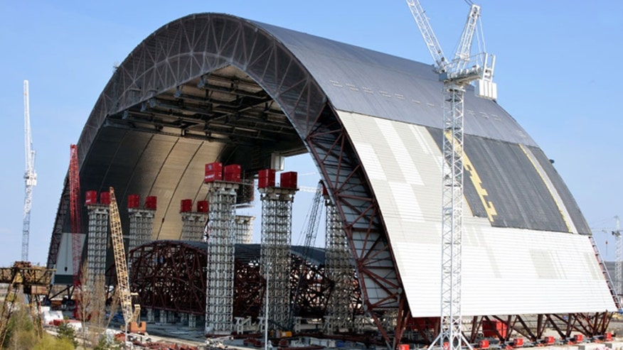
  • The first half of the arch has already been completed and sits in a waiting position near reactor four until the second half is finished.SSE Chernobyl NPP photo
Ukraine's political and economic meltdown could spell doom - or at least delay - for a containment dome being built over Chernobyl.
Construction of the coated steel, climate-controlled sarcophagus was begun in 2010 to cover the site of the infamous 1986 meltdown, scene of the worst nuclear accident in history. 
.
But finishing the $2.1 billion project requires money and, likely, stability from the Ukraine government and international backers. Planned in sections comprised of two 300-foot-high arches that will span the site and then be walled on the sides, the project will never be completed by the original goal of 2015, officials acknowledge.

“Delay of the project should end immediately."- Roksolana Stojko-Lozynskyj, of the Ukranian Congress Committee
And given Ukraine's economic and political crisis, it's anyone's guess when the project, designed to last at least 100 years, will ever be completed. Called the New Safe Confinement Arch project, it is  funded by Ukraine and the European Bank for Reconstruction and Development. But Ukraine is broke, and donor nations may be leery of investing amid political instability.
.
“In our financial analysis we are of course making the working assumption that it will not receive any money from Ukraine in the near term,” Vince Novak, director of nuclear safety at the EBRD said in a recent interview with Nuclear Engineering magazine.
.
Chronically cash-strapped Ukraine has been in turmoil for months after a revolution ousted President Viktor Yanukovych, who had backed out of a deal to join the European Union in favor of a funding package from Russia. In recent weeks, tensions between Ukraine and Russia have flared, after Russia invaded Crimea and signaled that it may want an even bigger piece of its neighbor.
.
The planned structure would entomb the reactor building and be built of steel coated with polycarbonate, which is effective at degrading radiation levels. The first half of the arch was recently completed and is being held in a makeshift waiting area near the plant site, but the second half is on hold. 
Novak said it is not just funding that is holding up the project, some 85 miles north of Kiev.
“It [the delay] has been largely driven by the finalization design and to a certain extent the design of the auxiliary system,” he told FoxNews.com.
.
The new containment cap would replace the existing sarcophagus which was constructed immediately after the reactor meltdown in 1986. Made from concrete, the original containment structure at the reactor building is starting to deteriorate, leaving open the possibility that more radiation could escape if there is even a partial collapse.
.
Activists and experts say containing Chernobyl is a top priority.
“Delay of the project should end immediately,” Roksolana Stojko-Lozynskyj, of the Ukrainian Congress Committee, told FoxNews.com. “It ecologically vital to the region and should go on regardless of what is currently happening. It’s not only a matter of safety for Ukraine but for Europe as a whole.”
.
The Chernobyl disaster occurred in in April 1986 while Ukraine was still under the rule of the Soviet Union. It killed 31 immediately, though thousands more are believed to have died or suffered from radiation poisoning. The nearby city of Pripyat was left a ghost town, and a 1,000-square-mile area around is dubbed the "Chernobyl Exclusion Zone, although some people insist on living there. 
.
Cancers and deformities have been reported in the last few decades in the region in Northern Ukraine as well as nearby Belarus.
It would seem that it is in everyone's interest to seal off the source of the deadliest nuclear accident in history.
.
“You would think Russia would have an interest in finishing the structure,” Jonathan Lesser, an economist specializing in energy, told FoxNews.com. “Then again, they could use completion as yet another bullying point to continue their moves on Ukraine.”