The Hellenic Navy (HN) (Greek: Πολεμικό Ναυτικό, Polemikó Naftikó, abbreviated ΠΝ) is the naval force of Greece, part of the Greek Armed Forces. The modern Greek navy has its roots in the naval forces of various Aegean Islands, which fought in the Greek War of Independence. During the periods of monarchy (1833–1924 and 1936–1973) it was known as the Royal Navy (Βασιλικόν Ναυτικόν, Vasilikón Naftikón, abbreviated ΒΝ).The total displacement of all the navy's vessels is approximately 150,000 tons.The motto of the Hellenic Navy is "Μέγα το της Θαλάσσης Κράτος" from Thucydides' account of Pericles' oration on the eve of the Peloponnesian War. This has been roughly translated as "Great is the country that controls the sea". The Hellenic Navy's emblem consists of an anchor in front of a crossed Christian cross and trident, with the cross symbolizing Greek Orthodoxy, and the trident symbolizing Poseidon, the god of the sea in Greek mythology. Pericles' words are written across the top of the emblem. "The navy, as it represents a necessary weapon for Greece, should only be created for war and aim to victory."...............The Hellenic Merchant Marine refers to the Merchant Marine of Greece, engaged in commerce and transportation of goods and services universally. It consists of the merchant vessels owned by Greek civilians, flying either the Greek flag or a flag of convenience. Greece is a maritime nation by tradition, as shipping is arguably the oldest form of occupation of the Greeks and a key element of Greek economic activity since the ancient times. Nowadays, Greece has the largest merchant fleet in the world, which is the second largest contributor to the national economy after tourism and forms the backbone of world shipping. The Greek fleet flies a variety of flags, however some Greek shipowners gradually return to Greece following the changes to the legislative framework governing their operations and the improvement of infrastructure.Blogger Tips and Tricks
This is a bilingual blog in English and / or Greek and you can translate any post to any language by pressing on the appropriate flag....Note that there is provided below a scrolling text with the 30 recent posts...Αυτό είναι ένα δίγλωσσο blog στα Αγγλικά η/και στα Ελληνικά και μπορείτε να μεταφράσετε οποιοδήποτε ποστ σε οποιαδήποτε γλώσσα κάνοντας κλικ στη σχετική σημαία. Σημειωτέον ότι παρακάτω παρέχεται και ένα κινούμενο κείμενο με τα 30 πρόσφατα ποστς....This is a bilingual blog in English and / or Greek and you can translate any post to any language by pressing on the appropriate flag....Note that there is provided below a scrolling text with the 30 recent posts...Αυτό είναι ένα δίγλωσσο blog στα Αγγλικά η/και στα Ελληνικά και μπορείτε να μεταφράσετε οποιοδήποτε ποστ σε οποιαδήποτε γλώσσα κάνοντας κλικ στη σχετική σημαία. Σημειωτέον ότι παρακάτω παρέχεται και ένα κινούμενο κείμενο με τα 30 πρόσφατα ποστς.........

Showing posts with label Environment. Show all posts

Friday, December 19, 2014

Ice pancakes appear on river..[ 5038 ]

Mysterious ice pancakes appear on Scottish river

By Barry Neild, CNN
December 18, 2014 -- Updated 1536 GMT (2336 HKT)
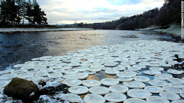
Biologist Jamie Urquhart found the strange ice pancakes near the River Dee in Scotland.

London (CNN) -- Here's another Scottish mystery to file alongside the Loch Ness Monster and Mel Gibson's accent in "Braveheart."
Ice pancakes.
These strange frozen saucers were found during a recent cold snap near the River Dee -- a salmon-filled waterway that passes by the British Queen's summer residence, Balmoral Castle, before heading eastwards to the coastal city of Aberdeen.
River Dee Trust biologist Jamie Urquhart made the discovery and took the photos at Lummels Pool, Birse -- several miles downstream of Balmoral.
The trust said it was initially unsure what caused the pancakes, but supects they're caused by a rare phenomenon in which foam freezes in a swirling eddy.
.
Rare occurrence
"Perhaps each disc grew when smaller pieces of unfrozen foam struck the disc, adhered and then froze in place," it wrote on its website.
"The raised rims are undoubtedly due to the collisions but what about the inner lines?
"The air temperature was colder at night due to the clear-sky conditions but warmer in the day, meaning the discs may have grown at night, then during the day, when the discs softened in the sun, further collisions between the 'pancakes' caused the rims to be pushed up.
"The next night further growth would have occurred, followed by a new rim the next day."
The Trust said it's the first time the pancakes, more commonly found in the Antarctic or the Baltic Sea, have been seen on the River Dee.

Sunday, December 7, 2014

Eruption could destroy Japan ..[ 4995 ]

Colossal volcanic eruption could destroy Japan 

http://dutchsinse.com/10232014-large-...
.
 Video : 

.

Sunday, November 30, 2014

Titan sea...[ 4965 ]

Extraterrestrial oceanography reveals depths of Titan sea

The Cassini spacecraft – which has been orbiting Saturn since 2004 – used radar to sound the depths of a sea of liquid methane and ethane on Saturn’s large moon Titan.
Cassini radar data reveal the depth of a liquid methane/ethane sea on Saturn's moon Titan near the mouth of a large, flooded river valley.  Image via NASA/JPL-Caltech/ASI/Cornell
Cassini radar data has revealed the depth of a liquid methane/ethane sea on Saturn’s moon Titan near the mouth of a large, flooded river valley. Image via NASA/JPL-Caltech/ASI/Cornell

The Cassini mission has been orbiting Saturn since 2004, weaving in and among its moons and rings, and now we have this image taken on Saturn’s large moon Titan on August 21, 2014. It shows the mouth of a flooded river valley on Titan, which is a moon completely shrouded by clouds, whose surface has been revealed only by Cassini’s radar. During this recent flyby, the craft used radar to sound the depths of the largest of Titan’s methane/ethane seas. This sea on Saturn’s moon – called Kraken Mare – was discovered in 2007 by Cassini and named for a legendary sea monster. Cassini’s Titan flyby on August 21 included a segment designed to collect altimetry (or height) data, using the spacecraft’s radar instrument, along a 120-mile (200-kilometer) shore-to-shore track on Kraken Mare. For a 25-mile (40-kilometer) stretch of this data, along the sea’s eastern shoreline, Cassini’s radar beam bounced off the sea bottom and back to the spacecraft, revealing the sea’s depth in that area to range from 66 to 115 feet (20 to 35 meters).
These new findings are being presented this week at the Division for Planetary Sciences Meeting of the American Astronomical Society held in Tucson, Arizona.
Read more about Cassini’s August 21 flyby of Titan, from JPL
Titan in natural color.  All we are seeing here, in this composite image, are this moon's uppermost clouds.  The Cassini spacecraft obtained the images to make this composite during a Titan flyby on April 16, 2005.  Image via NASA/JPL
This natural-color composite of Titan shows only the uppermost layer of the moon’s thick atmosphere. The Cassini spacecraft obtained the images to make this composite during a Titan flyby on April 16, 2005. Image via NASA/JPL

View larger. | Seas on Saturn's moon Titan, via Cassini spacecraft
The mosaic just above, created by Cassini via many flybys of Titan over nearly a decade, shows the seas of Titan in context.  NASA said of this image:


Seas on Saturn’s moon Titan, revealed by radar taken by the Cassini spacecraft from 2004 to 2013.


This colorized mosaic from NASA’s Cassini mission shows the most complete view yet of Titan’s northern land of lakes and seas. Saturn’s moon Titan is the only world in our solar system other than Earth that has stable liquid on its surface. The liquid in Titan’s lakes and seas is mostly methane and ethane … The data were obtained by Cassini’s radar instrument from 2004 to 2013. In this projection, the north pole is at the center. The view extends down to 50 degrees north latitude. In this color scheme, liquids appear blue and black depending on the way the radar bounced off the surface. Land areas appear yellow to white.
Kraken Mare, Titan’s largest sea, is the body in black and blue that sprawls from just below and to the right of the north pole down to the bottom right. Ligeia Mare, Titan’s second largest sea, is a nearly heart-shaped body to the left and above the north pole. Punga Mare is just below the north pole.
The area above and to the left of the north pole is dotted with smaller lakes. Lakes in this area are about 30 miles (50 kilometers) across or less.
Most of the bodies of liquid on Titan occur in the northern hemisphere. In fact nearly all the lakes and seas on Titan fall into a box covering about 600 by 1,100 miles (900 by 1,800 kilometers). Only 3 percent of the liquid at Titan falls outside of this area.
It’s very interesting to remember that, before Cassini, we had never peered through Titan’s clouds and had no idea these seas of liquid – albeit liquid methane and ethane – existed. Now we not only know they exist, but we have also sounded their depths. It’s a stunning achievement and yet another illustration of the power of robot spacecraft!
Bottom line: The Cassini spacecraft – which has been orbiting Saturn since 2004 – used radar to sound the depths of a sea of liquid methane and ethane on Saturn’s large moon Titan.

Thursday, November 20, 2014

Epic snowfall in New York; at least 8 confirmed deaths.[ 4927 ]

Western New York communities slammed by historic snow brace for two more feet

>
A new blast of snow is pounding Buffalo Thursday morning, piling more misery on a city already buried by an epic, deadly snowfall that could leave some areas with more than 8 feet of snow on the ground when it's all done.
"It's going to come down with just as much intensity," Rich Tobe, the deputy county executive, told The Buffalo News.
The Buffalo area found itself buried under as much as 5 1/2 feet of snow Wednesday, with another lake-effect storm expected to bring an average of 2 more feet by late Thursday. The New York State Electric and Gas Corporation said more than 4,000 homes are without power in the region, the report said.
The storms' death toll hit eight, with at least four heart attacks, when a man in his 60s was stricken a day earlier while using a snow blower.
"Heavy lake effect snow will result in very difficult or nearly impossible travel at times in the heaviest portion of the band," the National Oceanic and Atmospheric Administration said. The storm is expected to last until late Friday morning. But forecasters say a rapid weekend warmup, with temperatures as high as 60 and heavy rain, could turn all that snow into floods.
VIDEO: Storm blamed for at least 8 deaths
Gov. Andrew Cuomo is advising western New Yorkers to "stay home and take it easy" while crews clear Buffalo-area roads and highways clogged with several feet of snow from lake-effect storms. The storm trapped more than 100 vehicles along the New York State Thruway. But Cuomo said those stranded on the Thruway have been removed other than a few truck drivers who opted to stay.
Interstate 90 remained closed from Rochester to the Pennsylvania line.
Some Buffalo-area schools are closed for the third consecutive day. All schools in the cities of Buffalo and Lackawanna are closed Thursday, as are suburban districts in the towns of Amherst, Tonawanda, Hamburg, Orchard Park, Lancaster, Cheektowaga and West Seneca.
The University at Buffalo's North and South campuses are closed, along with Erie Community College's campuses.  Five other colleges in the Buffalo area have also called off classes.
Authorities say residents of a suburban Buffalo mobile home park are being evacuated after their roofs began to collapse under the weight of heavy snow.
Fire Commissioner Peter Spilsbury of the Seneca Hose Fire Co. says 15 to 20 people are being evacuated from their homes at the French Quarter Mobile Home Park in the town of West Seneca, just east of Buffalo.
One volunteer firefighter reportedly said crews had to rip a door off of one of the homes to free a trapped woman.


Amtrak says the Maple Leaf, between New York City and Toronto, and Trains 63 and 64 will be restored starting Thursday, with delays expected. Service was suspended Tuesday because of the heavy snowfall and travel bans were issued by local officials in Erie County, which has Amtrak stations in Buffalo and suburban Depew.
Other Amtrak service between Albany-Rensselaer and Buffalo or Cleveland remains temporarily suspended through Thursday afternoon. This includes Amtrak Empire Service and Lake Shore Limited trains scheduled through mid-day.
Amtrak service north, east and south of Albany continues to operate.

Thursday, November 13, 2014

Caribbean Islands..[ 4909 ]

Five Sun-Drenched Caribbean Islands to Visit This Winter

Best Caribbean islands to visit with the family By

Family Vacation Destinations

Martinique Martinique (Flickr: Luc Viatour)
With winter holidays well on the way, there’s no time like the present to set sights on a sun and fun filled escape to the colorful Caribbean. Covered in rainforests, dotted with volcanoes, bursting with wildlife and waterfalls, all surrounded by endless white sand beaches, the Caribbean islands are a favorite destination for families with kids of all ages and interests. A vacation to these five welcoming Caribbean islands offers a recipe for fun:

Need help planning your Caribbean Getaway? Chat/Talk with our experts - a free service by MiniTime

Dolphin Encounters in the Bahamas Dolphin Encounters in the Bahamas (Dolphin Encounters in the Bahamas)
The Bahamas have all the makings of a great vacation for families craving a perfect mix of relaxation and recreation. Best known for heartbreakingly beautiful beaches, the Bahamas also boast sloop sailing and sports on land and water for every season. Treat the kids to the Dolphin Experience on Grand Bahama Island, where friendly Atlantic bottlenose dolphins frolic in one of the largest dive programs in the Caribbean. During Carnival and street festivals, be on the lookout for Moko Jumbies, the stilt-walking symbols of freedom.

Martinique. Beyond its string of spectacular beaches and charming French-infused culture, Martinique boasts a bucket-load of sports and more than a fair share of recreational activities for kids. Zip from tree to tree on an adventure trail along catwalks through the trees at Trois-Ilets at Mongofila, a gigantic theme park full of fun things to do for kids of all ages. Children and their parents get a kick out of water trampolines, waterslides, floating swings and climbing walls at the family-friendly Maya Beach Club at Plage de l'Hotel Caritan.

Isla Mujeres Isla Mujeres (Flickr: Thomassin Mickaël)
Isla de Mujeres, Mexico is just a short but sweet boat ride from bustling Cancun. The beaches of Isla de Mujeres, the Island of Women, are peaceful and sometimes deserted. The Mayans dedicated Isla de Mujeres to Ixchel (otherwise known as goddess O), the jaguar goddess of midwifery and medicine. Families with kids who like to explore sandy stretches of clear turquoise water against soft white sand will benefit from a visit to Isla de Mujueres. Kids appreciate the Isla Mujeres Turtle Farm, a government sponsored hatchery and rehabilitation center for endangered sea turtles which are treated all year round.

The Cayman Islands are an archipelago of three islands 90 miles south of Cuba. The Caymans are widely known for world-class scuba diving, watersports, and golf courses. The whole family can while away days on the popular Seven Mile Beach, and at Rum Point, the calm waters are especially relaxing. Swim and mingle with stingrays at Stingray City, an area of sandbars found in the North Sound of Grand Cayman where a flurry of friendly stingrays congregate in the shallow waters.

(TRIP PLAN:Find out how one travel expert and her family spent their Caribbean vacation.)

Dominican Republic Dominican Republic (Flickr: Ronald Saunders)
With lots of islands to choose from, the Dominican Republic (The DR) makes an ideal getaway for families who like the kid-friendly amenities of its all-inclusive resorts, especially on the idyllic, sand-swept eastern island of Punta Cana. Kids can channel the famous Domincan baseball player Sammy Sosa in batting cages, practice archery, and scale a climbing wall at the kid-focused action park at the Paradisus Punta Cana Resort.

Sophia LaMonica contributed this to MiniTime.

Tuesday, November 11, 2014

"Polar Vortex" ..[ 4902 ]

What is a Polar Vortex?

CNN|Added on November 10, 2014 

CNN's Jennifer Gray explains what is a "Polar Vortex" and what to do if you find yourself in very cold temperatures.
 . 

Saturday, October 25, 2014

Αμεση αποζημίωση των πληγέντων απο τις πλημμύρες.[ 4848 ]

Αμεση αποζημίωση των πλημμυροπαθών στην Αττική

Η ΚΑΘΗΜΕΡΙΝΗ || 25 Οκτωβρίου 2014


Την άμεση αποζημίωση των πληγέντων απο τις πλημμύρες στην Αττική, ανακοίνωσε ο πρωθυπουργός μετά την έκτακτη σύσκεψη στο Κέντρο Επιχειρήσεων Πολιτικής Προστασίας στο Χαλάνδρι, τη νύχτα της Παρασκευής. Ο κ. Σαμαράς υπογράμμισε ότι όσοι έχουν υποστεί ζημιές θα αποζημιωθούν το ταχύτερο δυνατόν, καθώς το υπουργείο Οικονομικών έλαβε εντολή να αποδεσμεύσει τα αναγκαία ποσά την Δευτέρα.

«Απο το πρωί του Σαββάτου από θα ξεκινήσει μια αναλυτική καταγραφή ζημιών, η οποία και θα ολοκληρωθεί τη Δευτέρα», δήλωσε ο πρωθυπουργός . «Εχει δοθεί εντολή στο υπουργείο Οικονομικών να αποδεσμεύσει αμέσως τα χρήματα που είναι αναγκαία για κάθε πληγέντα δήμο. Κι επομένως, θα αποζημιωθούν εκείνοι οι οποίοι έχουν υποστεί αυτές τις καταστροφές όσο το δυνατόν πιο γρήγορα».

Ο κ. Σαμαράς πρόσθεσε ότι αναμένει από τις υπηρεσίες «εισήγηση για στοχευμένες παρεμβάσεις που πρέπει να γίνουν σε αντιπλημμυρικά έργα στις περιοχές, όπου μια ζωή βλέπουμε να δημιουργείται το ίδιο πρόβλημα». «Λόγου χάρη στα σύνορα Περιστερίου και Ιλίου, στην περιοχή Ρουπάκι ή στη Θηβών, στα όρια της Κοκκινιάς ή στη λεωφόρο Δημοκρατίας στο Μενίδι» τόνισε ο πρωθυπουργός.
Χωρίς εισοδηματικά κριτήρια θα διατεθούν οι κρατικές αποζημιώσεις στους πληγέντες από τις καταστροφικές βροχοπτώσεις και πλημμύρες που χτύπησαν την Αττική την Παρασκευή, όπως άφησε να εννοηθεί, μιλώντας στον ΣΚΑΪ, ο υπουργός Εσωτερικών Αργύρης Ντινόπουλος. Ο υπουργός Εσωτερικών δεν αποκάλυψε το ακριβές μέγεθος των αποζημιώσεων που θα διαθέσει το κράτος, τονίζοντας πως το ύψος του κονδυλίου που θα δεσμεύσει το υπουργείο Οικονομικών θα αποσαφηνιστεί όταν οι υπηρεσίες θα αποκτήσουν πληρέστερη εικόνα για το μέγεθος των ζημιών.
Καταγραφή των ζημιών κάνουν από το πρωί τα συνεργεία των Δήμων και των συναρμοδίων υπηρεσιών στο Περιστέρι, τη Νίκαια και τις υπόλοιπες περιοχές που επλήγησαν από τη χθεσινή σφοδρή νεροποντή. Σπίτια και μαγαζιά πλημμύρισαν, κυρίως στον Πειραιά και σε δυτικά προάστια, δρόμοι έγιναν ποτάμια, με αποτέλεσμα άνθρωποι και αυτοκίνητα να παρασυρθούν από τα ορμητικά νερά, οδηγοί να εγκλωβιστούν και να επικρατήσει χάος. Στις μαρίνες προκλήθηκαν ζημιές σε σκάφη από τη θαλασσοταραχή, δένδρα έπεσαν σε δρόμους και σε κολώνες της ΔΕΗ, με αποτέλεσμα σε πολλές περιοχές να σημειωθούν διακοπές ρεύματος, από τις οποίες δεν γλίτωσε ούτε η Βουλή των Ελλήνων. Ευτυχώς μπήκε σε λειτουργία η γεννήτρια.
Παράλληλα, ξεκαθαρίζεται ότι δεν υπάρχουν αγνοούμενοι στο γκαράζ του σούπερ μάρκετ στο Ίλιον, σύμφωνα με τον Γενικό Γραμματέα Πολιτικής Προστασίας Σεραφείμ Τσόκα, ο οποίος δήλωσε πως δεν υπάρχουν αναφορές αγνοουμένων.
Τηλεφωνικό κέντρο για την ευκολότερη καταγραφή των ζημιών που προκλήθηκαν σε κατοικίες στον Πειραιά, θα λειτουργήσει απο σήμερα στο Δήμο, ενώ οι επαγγελματίες που επλήγησαν, θα μπορούν να απευθύνονται στη Διεύθυνση Πολιτικής Προστασίας της Περιφέρειας Αττικής, που έχει και την αρμοδιότητα, όπως αποφασίστηκε κατά την σύσκεψη του Δημάρχου Γιάννη Μώραλη, στην οποία συμμετείχαν ο Αντιπεριφερειάρχης Πειραιά Γιώργος Γαβρίλης οι αντιδήμαρχοι και ο Γενικός Γραμματέας του Δήμου Πειραιά Βασίλης Ταταρόπουλος.
Σύμφωνα με τον κύριο Τσόκα, προβλήματα έχουν σημειωθεί σε 10 δήμους ενώ έχουν παρασυρθεί από τα νερά 250 με 300 αυτοκίνητα. Επίσης ζημιές υπάρχουν σε σπίτια και ήδη βρίσκεται σε εξέλιξη η διαδικασία καταγραφής τους. Μέσα σε μιάμιση ώρα έπεσαν 14 εκατοστά νερού ενώ αν έβρεχε όλη ημέρα υπό κανονικές συνθήκες το ύψος της βροχής θα έφθανε τα 5 εκατοστά. Η Πυροσβεστική δέχθηκε χιλιάδες τηλεφωνήματα ενώ συνέδραμε σε 850 περιπτώσεις, από τις οποίες 630 αφορούσαν αντλήσεις υδάτων, 150 κοπές δέντρων και τα υπόλοιπα άλλες παροχές που σχετίστηκαν με την κακοκαιρία.
Παράλληλα, οι Δήμαρχοι Περιστερίου και Ίλιον κ.κ Α. Παχατουρίδης και Ν. Ζενέτος παρείχαν το βράδυ προσωρινή στέγαση σε οικογένειες που χρειάστηκαν βοήθεια.
Η πρώτη αποτίμηση των ζημιών αναμένεται να ολοκληρωθεί εντός του Σαββατοκύριακου, ενδεχομένως και σήμερα Σάββατο.

Friday, October 24, 2014

Solar eclipse..[ 4846 ]

Time-lapse shows solar eclipse

Ken Tillis|Added on October 23, 2014 

Time-lapse video shows the solar eclipse over Denver on October 23, 2014.

Sunday, October 19, 2014

Beijing Marathon under smog [ 4825 ]

Beijing Marathon runners wear masks to combat smog from pollution

APTOPIX China Beijing_Cham640360.jpg
October 19, 2014: Runners wearing masks to protect themselves from pollutants jog past Chang'an Avenue near Tiananmen Square shrouded in haze while taking part in the 2014 Beijing International Marathon. (AP Photo/Andy Wong)

Despite heavy pollution blanketing Beijing on Sunday, an international marathon went ahead, with face masks and sponges among the equipment used by competitors to battle the smog.
The 34th Beijing International Marathon began at Tiananmen Square with many of the tens of thousands of participants wearing face masks. The 26.2-mile course ended at the Chinese capital's Olympic Park, on a day when buildings across the city disappeared into the gray-tinged mist.
"Actually, on a normal day, nobody would run in such conditions," said participant Liu Zhenyu, a computer engineer. "But the event is happening today, so what can we do?"
About 30,000 people were expected to take part in the marathon and the half-marathon. The organizing committee made 140,000 sponges available at supply stations along the marathon route so runners could "clean their skin that is exposed to the air," the Beijing News reported.
The men's and women's marathon winners were both from Ethiopia. Girmay Birhanu Gebru won the men's race in 2 hours, 10 minutes, 42 seconds, while Fatuma Sado Dergo won the women's in 2:30:3.
"Today the smog did have a little impact on my performance, but not a major one," said China's Gong Lihua, who came in third in the women's race.
An update Saturday night on the official microblog of the marathon, which was hosted by the Chinese Athletic Association and the Beijing Municipal Bureau of Sports, said "there might be slight or moderate smog." It asked competitors to take measures according to their own health, and advised the elderly and people with respiratory diseases to carefully consider whether to participate.
But the air Sunday was deemed severely polluted, according to the real-time monitoring of Beijing's environmental center. It was the most serious level on China's air quality index, and came with a warning for children, the elderly and the sick to stay indoors, and for everyone to avoid outdoor activities.
The U.S. Embassy, which tracks the Beijing air from a monitoring station on its roof and uses a different air quality index, said the air was hazardous. It gave a reading of 344 micrograms per cubic meter of PM2.5 particulate matter. The World Health Organization considers 25 micrograms within a 24-hour period a safe level.
The marathon's organizing committee said late Saturday that postponing the event would be difficult because of all the planning that had gone into it, and asked competitors to understand, the Beijing News reported. It said 46 percent of the competitors had traveled from abroad and other parts of China to take part.
China's pollution is notorious following years of rapid economic development. Combating the problem has shot up the agenda of the ruling Communist Party, which is under pressure from citizens who are tired of breathing in smog.

Saturday, October 18, 2014

Nuclear reactors near volcanos..[ 4819 ]

Nuclear reactors near active volcanos in Japan called unsafe

Japan Nuclear Volcanos-1.jpg
This June 2013 photo shows No. 1, right, and No. 2 at Sendai nuclear power station in Sendai, Kagoshima prefecture, southwestern Japan. A prominent volcanologist disputed Japanese regulators' conclusion that two nuclear reactors were safe from a volcanic eruption in the next few decades, saying Friday, Oct. 17, 2014 that such a prediction was impossible. A cauldron eruption at one of several volcanos surrounding the Sendai nuclear power plant could not only hit the reactors but could cause a nationwide disaster, said Toshitsugu Fujii, head of a government-commissioned panel on volcanic eruption prediction. (AP Photo/Kyodo News) JAPAN OUT, CREDIT MANDATORY (The Associated Press)

A prominent volcanologist disputed Japanese regulators' conclusion that two nuclear reactors were safe from a volcanic eruption in the next few decades, saying Friday that such a prediction was impossible.
A cauldron eruption at one of several volcanos surrounding the Sendai nuclear power plant in southern Japan could not only hit the reactors but could cause a nationwide disaster, said Toshitsugu Fujii, head of a government-commissioned panel on volcanic eruption prediction.
Nuclear regulators last month said two Sendai reactors fulfilled tougher safety requirements set after the 2011 Fukushima disaster. The regulators ruled out a major eruption over the next 30 years until the reactors' reach the end of their usable lifespan.
A surprise eruption of a volcano in central Japan on Sept. 27 has renewed concerns about the volcanos in the region.
"It is simply impossible to predict an eruption over the next 30 to 40 years," Fujii said. "The level of predictability is extremely limited."
He said at best an eruption can be predicted only a matter of hours or days.
Heavy ash falling from an eruption would make it impossible to reach the plant, and could also affect many parts of the country including Tokyo, he said.
The two Sendai reactors are the first ones approved under the new safety requirement. Prime Minister Shinzo Abe is pushing to restart the two, and any of the country's 46 other workable reactors that are deemed safe, saying nuclear power is stable and relatively cheap compared to other energy source and key to Japan's economic recovery.

Thursday, October 16, 2014

Deadliest disaster in the Himalayas..[ 4811 ]

Tragedy in the Himalayas


CNN|Added on October 15, 2014

 Deadliest disasters in one of the world's most treacherous mountain ranges.
.

Deadliest disaster in the Himalayas..[ 4811 ]

Tragedy in the Himalayas


CNN|Added on October 15, 2014

 Deadliest disasters in one of the world's most treacherous mountain ranges.
.

Monday, October 13, 2014

ΣτΕ:κατεδάφιση των αυθαιρέτων στον αιγιαλό..[ 4793 ]


ΣτΕ: Υποχρεωτική η κατεδάφιση των αυθαιρέτων στον αιγιαλό
BHMA / Δευτέρα 13 Οκτωβρίου 2014 

ΣτΕ: Υποχρεωτική η κατεδάφιση των αυθαιρέτων στον αιγιαλό
Φωτογραφία αρχείου  - Η οριοθέτηση δεν δημιουργείται με νόμους και υπουργικές αποφάσεις

Αθήνα 
Η αυξημένη, επταμελής σύνθεση του Ε' Τμήματος του Συμβουλίου της Επικρατείας με την υπ' αριθμ. 3354/2014 απόφασή της υπογραμμίζει ότι «τα αυθαίρετα κτίσματα ανεγειρόμενα εν μέρει ή εν όλω εντός του αιγιαλού ή εντός της θάλασσας, κατεδαφίζονται υποχρεωτικώς».
Οι ειδικές διατάξεις περί αυθαιρέτων κατασκευών, αναφέρουν οι σύμβουλοι Επικρατείας, «αποσκοπούν στην άμεση και αποτελεσματική προστασία του αιγιαλού και του θαλασσίου χώρου και επιβάλλουν την αποκατάσταση της μορφής τους, η οποία έχει αλλοιωθεί με την χωρίς άδεια ανέγερση πάσης φύσεως τεχνικού έργου, κτίσματος ή κατασκευάσματος».

Τα αυθαίρετα κτίσματα, σημειώνουν οι σύμβουλοι Επικρατείας, που ανεγέρθηκαν χωρίς την προβλεπόμενη από τη νομοθεσία περί αιγιαλού διοικητική άδεια πρέπει, κατ' αρχήν, να κατεδαφίζονται οποτεδήποτε και αν έχει λάβει χώρα ανέγερσή τους, ακόμη δηλαδή και αν αυτά έχουν ανεγερθεί πριν από την οριοθέτηση του αιγιαλού με διοικητική πράξη, καθώς «ο αιγιαλός δεν δημιουργείται με σχετική πράξη της Πολιτείας, αλλά προκύπτει από φυσικά φαινόμενα, δηλαδή τις μεγαλύτερες αλλά συνήθεις αναβάσεις των κυμάτων, η δε προβλεπόμενη στον νόμο διαδικασία καθορισμού των ορίων του δεν αποσκοπεί παρά στη διαπίστωση του πραγματικού αυτού γεγονότος».

Παράλληλά, σημειώνει το ΣτΕ ότι η οριοθέτηση του αιγιαλού δεν δημιουργείται με νόμους και υπουργικές αποφάσεις, αλλά προκύπτει από φυσικά φαινόμενα, ενώ το Ανώτατο Ακυρωτικό Δικαστήριο κάνει σαφές ότι τα αυθαίρετα κτίσματα που βρίσκονται στον αιγιαλό χωρίς περιστροφές θα κατεδαφίζονται υποχρεωτικά και άμεσα.

Σύμφωνα με το ιστορικό της υπόθεσης, η κτηματική υπηρεσία Κυκλάδων στηριζόμενη σε έκθεση αυτοψίας του Λιμεναρχείου Σερίφου εξέδωσε πρωτόκολλο κατεδάφισης αυθαίρετου κτίσματος στον αιγιαλό οικισμού της Σερίφου. Παράλληλα, κάλεσε την ιδιοκτήτρια του ακινήτου να το κατεδαφίσει μέσα σε 15 ημέρες όπως προβλέπει η νομοθεσία.

Το επίμαχο  κτίσμα για το οποίο διατάχθηκε η κατεδάφιση του ανεγέρθηκε το 1960 ως αποθήκη με άδεια της τότε Χωροφυλακής Σερίφου και το 1993 με άδεια του Πολεοδομικού γραφείου Μήλου, επετράπη η αλλαγή χρήσης του από αποθήκη σε κατάστημα, όπου και λειτούργησε ως «μίνι μάρκετ».

Η ιδιοκτήτρια του καταστήματος προσέφυγε στην Δικαιοσύνη και ζητούσε να ακυρωθεί το πρωτόκολλο κατεδάφισης. Στην συνέχεια κατέθεσε αίτηση στην Κτηματική Υπηρεσία για επανακαθορισμό του αιγιαλού κατά τρόπο ώστε να εξαιρείται το επίμαχο κτίσμα, καθώς έχει αναγερθεί με νόμιμη άδεια. Όμως, το αίτημα  για επανακαθορισμό του αιγιαλού απερρίφθη.

Παρ' όλα αυτά η προσφυγή του ιδιοκτήτη του κτίσματος έγινε δεκτή, για καθαρά τυπικούς λόγους. Οι δικαστές έκαναν δεκτή την αίτηση ακύρωσης με το σκεπτικό ότι η άδεια ανέγερσης του επίμαχου κτίσματος είχε εκδοθεί πριν από την οριοθέτηση του αιγιαλού που έγινε το 1983 από την Νομαρχία Κυκλάδων, ενώ προσθέτουν ότι ούτε η άδεια ανέγερσης είχε ανακληθεί από την αρμόδια Πολεοδομική υπηρεσία.
Πηγή:Το Βήμα

Thursday, October 2, 2014

The best beaches in Greece! ..[ 4761 ]

Some of the best beaches in Greece! 

Δημοσιεύτηκε στις 21 Ιουλ 2012
Greece has more than 16,000 kilometers (9,320 miles) of coastline, 200,000 beaches, 6,000 islands (and islets). Greece's coastline is by far the longest coastline in the Mediterranean sea, and the tenth longest in the world. The deepest point in the Mediterranean Sea is called the "Calypso Deep", it is located in the Ionian Sea in Greece, and is 5,267 meters deep (17,280 feet). 
.

Mυστηριώδης γεωλογικός σχηματισμός της Σελήνης.[ 4760 ]


Τεράστια ορθογώνια τάφρος στη Σελήνη


Τεράστια ορθογώνια τάφρος στη Σελήνη
Ο μυστηριώδης γεωλογικός σχηματισμός εντοπίστηκε από τη NASA, Με κόκκινο έχει σημειωθεί το γεωλογικό σχήμα που αποτελεί την τάφρο
Kaλιφόρνια 
Ένα τεράστιο γεωλογικό σχηματισμό με σχήμα ορθογωνίου παραλληλογράμμου, θαμμένο λίγο κάτω από την επιφάνεια στη φωτεινή πλευρά της Σελήνης, ανακάλυψαν οι επιστήμονες με τη βοήθεια των ευρημάτων των «δίδυμων» δορυφόρων της αποστολής Grail της NASA.
Οι δορυφόροι το 2012 είχαν χαρτογραφήσει τις ανωμαλίες του βαρυτικού πεδίου του φεγγαριού, οι οποίες εξαρτώνται από τις διακυμάνσεις της επιφανειακής και υπόγειας γεωμορφολογίας.

Ο μυστηριώδης γεωλογικός σχηματισμός βρίσκεται κάτω από τη μεγαλύτερη «θάλασσα» της Σελήνης (τον λεγόμενο «Ωκεανό των Καταιγίδων») και ήταν άγνωστος έως τώρα. Η ανακάλυψη σημαίνει ότι ο «Ωκεανός» δεν προέρχεται από πτώση μεγάλου αστεροειδούς, όπως πίστευαν ως τώρα οι επιστήμονες, αλλά από τις τεκτονικές διεργασίες του ίδιου του φεγγαριού.

Η πρώτη σεληνιακή τάφρος

Η τεράστια υπόγεια πεδιάδα πλάτους περίπου 2.600 χιλιομέτρων πιστεύεται ότι αποτελεί απομεινάρι παλαιών τεκτονικών τάφρων, που αργότερα γέμισαν με λάβα. Είναι η πρώτη φορά που ανακαλύπτονται τέτοιες τάφροι στη Σελήνη, ενώ έχουν ήδη βρεθεί στον Άρη και στην Αφροδίτη. Παρόμοια τεκτονική γεωμετρία φαίνεται να υπάρχει στον Εγκέλαδο, το παγωμένο φεγγάρι του Κρόνου.

«Είναι εντυπωσιακό πόσο μεγάλος είναι αυτός ο υπόγειος γεωμετρικός σχηματισμός. Καλύπτει περίπου το 17% της επιφάνειας της Σελήνης, μια επιφάνεια ισοδύναμη με τη Β. Αμερική, την Ευρώπη και την Ασία μαζί», δήλωσε ο καθηγητής γεωφυσικής Τζέφρι Άντριους Χάνα της Σχολής Μεταλλειολόγων του Πανεπιστημίου του Κολοράντο, επικεφαλής της ερευνητικής ομάδας, που έκανε τη σχετική δημοσίευση στο περιοδικό «Nature».

«Ποτέ κανείς δεν πίστευε ότι θα έβλεπε ένα τετράγωνο ή ένα παραλληλόγραμμο τόσο μεγάλο σε οποιονδήποτε πλανήτη. Αναρωτιέται επίσης κανείς τι μπορεί να κρύβεται κάτω από τις επιφάνειες όλων των άλλων πλανητών του ηλιακού μας συστήματος», πρόσθεσε.

Όσον αφορά τον μηχανισμό που δημιούργησε τον ιδιόμορφο γεωλογικό σχηματισμό, σύμφωνα με τους επιστήμονες, το υπέδαφος αυτής της περιοχής περιέχει πολλά φυσικά ραδιενεργά στοιχεία, όπως ουράνιο, θόριο και κάλιο, τα οποία θα θέρμαναν τον φλοιό του φεγγαριού, όταν αυτό βρισκόταν σε νεαρή ηλικία. Όταν αργότερα ο φλοιός ψύχθηκε, θα δημιουργήθηκαν ρωγμές στην επιφάνειά του, ανοίγοντας έτσι βαθιές τάφρους. Στη Γη η ανάλογη γεωλογική διαδικασία συνήθως παράγει εξάγωνα σχήματα.

Η ακριβής ημερομηνία δημιουργίας του βυθισμένου παραλληλογράμμου δεν μπορεί να υπολογιστεί ακόμη, αλλά εκτιμάται ότι οι τάφροι του γέμισαν με βασαλτική λάβα από τα τότε ενεργά ηφαίστεια του δορυφόρου μας, πριν από περίπου 3,5 δισεκατομμύρια χρόνια.

Οι σκούροι «λεκέδες» της λάβας πάνω στο φωτεινότερο φόντο της επιφάνειας του «Ωκεανού των Καταιγίδων» (Oceanus Procellarum) ήταν αυτό που είχε δημιουργήσει ένα πανάρχαιο μυστήριο: την πεποίθηση των ανθρώπων ότι βλέπουν το πρόσωπο ενός ανθρώπου στο φεγγάρι. Οι παλαιοί αστρονόμοι είχαν εξάλλου εσφαλμένα περάσει για «θάλασσες» όλες τις μεγάλες πεδιάδες του φεγγαριού, γι' αυτό τις είχαν ονομάσει έτσι.

Sunday, September 28, 2014

'Eκρηξη ηφαιστείου στην Ιαπωνία...[ 4725 ]

Εκρηξη ηφαιστείου στην Ιαπωνία - Φόβοι για δεκάδες θύματα

Κυριακή, 28 Σεπτεμβρίου 2014 17:14// EURONEWS

Ιαπωνία: Πάνω από 30 εντοπίστηκαν σε κατάσταση «καρδιοαναπνευστικής» ανακοπής

Πάνω από 30 ορειβάτες εντοπίστηκαν σε κατάσταση «καρδιοαναπνευστικής ανακοπής», στο ηφαίστειο Οντάκε της Ιαπωνίας, που εξερράγη το μεσημέρι του Σαββάτου. Πρόκειται για ένα όρο που χρησιμοποιείται από τις ιαπωνικές αρχές, μέχρι ο θάνατος των θυμάτων να επιβεβαιωθεί από τους γιατρούς. Το ηφαίστειο βρίσκεται περίπου 200 χιλιόμετρα δυτικά του Τόκιο και έχει ύψος 3.067 μέτρα. Εξερράγη την ώρα που εκατοντάδες ορειβάτες, μεταξύ αυτών και παιδιά, σκαρφάλωναν στις πλαγιές του.
.====
Video :

==  
ΔΙΑΒΑΣΤΕ ΣΧΕΤΙΚΑ
  •  Ιαπωνία: Πάνω από 30 εντοπίστηκαν σε κατάσταση «καρδιοαναπνευστικής» ανακοπής 28/09 10:40
  •  Ιαπωνία: Περίπου 40 αποκλεισμένοι μετά την έκρηξη ηφαιστείου 28/09 07:15
  • Μία νεκρή από την έκρηξη ηφαιστείου στην Ιαπωνία 27/09 18:39 
  • Τραυματίες από έκρηξη ηφαιστείου στην Ιαπωνία 27/09 13:09

Monday, September 22, 2014

Ασύλληπτος παραμένει ο κροκόδειλος της Κρήτης.[ 4679 ]

Ασύλληπτος παραμένει ο Σήφης ο κροκόδειλος,
Cretapost.gr  22/9/2014 // Γράφτηκε από  diaxeiristis
Ασύλληπτος παραμένει ο Σήφης ο κροκόδειλος, μετά και από τις αποτυχημένες προσπάθειες του διάσημου ερπετολόγου, Ολιβιέ Μπερά, ο οποίος βρέθηκε για τρεις μέρες στην Κρήτη, προκειμένου να βοηθήσει στη σύλληψη του ζώου.


Ο Σήφης, ο οποίος φαίνεται ότι είναι κροκόδειλος του Νείλου, θεωρείται σχετικά παχύς, καθώς η τροφή που υπάρχει στο φράγμα είναι άφθονη (πάπιες, νερόκοτες κτλ.) και για αυτό το λόγο δεν εισήλθε μέχρι τώρα στις σωστά τοποθετημένες παγίδες, παρόλο που τις πλησίασε πολλές φορές.

Ο κύριος Μπερά και οι συνεργάτες του έδωσαν συμβουλές για τη βελτίωση των παγίδων, όπως την αλλαγή των δολωμάτων κάθε τρεις μέρες και την χρήση ενός πιο ζουμερού δολώματος, όπως είναι το συκώτι, αντί για κότες.

Παρόλο που η τοπική κοινωνία έχει δώσει το όνομα “Σήφης” στον κροκόδειλο, δεν είναι ακόμα γνωστό εάν είναι αρσενικός ή θηλυκός, ενώ αξίζει να σημειωθεί ότι ο κροκόδειλος έχει περάσει ένα μεγάλο μέρος της ζωής του σε αιχμαλωσία. Το μέγεθος του Σήφη είναι γύρω στο ένα μέτρο και 70 εκατοστά, μέγεθος που παραπέμπει σε ηλικία τεσσάρων έως επτά ετών, σύμφωνα με τον Μπερά.

Η επιχείρηση σύλληψης του Σήφη

Από τις 26 έως τις 28 Αυγούστου πραγματοποιήθηκε επιχείρηση σύλληψης του Σήφη του κροκόδειλου στο Φράγμα Ποταμών στο Ρέθυμνο. Στην επιχείρηση, εκτός από τον Ολιβιέ Μπερά, που ειδικεύεται στη σύλληψη κροκοδείλων, έλαβαν μέρος η συνεργάτης του Μαρτίν Βέλιτς, μέλη της ομάδας άμεσης επέμβασης, υπάλληλοι της Διεύθυνσης Δασών Ρεθύμνου, του Οργανισμού Ανάπτυξης Κρήτης και της Ελληνικής Αστυνομίας, καθώς και εθελοντές.

Η μορφολογία της περιοχής (12 χιλιόμετρα ακτογραμμών), του πυθμένα με τις απότομες εναλλαγές βάθους (μέγιστο βάθος 50 μ.), όπως και η ύπαρξη παλαιότερων δένδρων σε κατάκλιση και νεότερης υδροχαρούς βλάστησης που χρησιμοποιούνται ως καταφύγιο του ζώου, δημιούργησαν ιδιαίτερα δυσμενείς συνθήκες για την επιχείρηση.

Ο τρόπος που επελέγη τελικά ήταν η χρήση μικρής πλαστικής βάρκας, με μηχανή 5 ίππων και κουπιά, για την ανίχνευση της ακτογραμμής και τον εντοπισμό του ζώου. Στην ακτή υπήρχε εφεδρική λέμβος μεγαλύτερου κυβισμού με έμπειρους χειριστές – ναυαγοσώστες, ώστε να είναι δυνατή η άμεση επέμβαση σε οποιοδήποτε ενδεχόμενο.

Εάν η πλαστική βάρκα είχε προβλήματα λόγω της βλάστησης στην προσέγγιση του ζώου, θα χρησιμοποιούνταν κανό με κουπιά. Εκτός από τον Olivier Behra,  στις βάρκες επέβαινε και ο ερπετολόγος και μέλος της ομάδας άμεσης επέμβασης, κος Πέτρος Λυμπεράκης.

Ο κύριος Μπερά, από την αρχή γνωστοποίησε την επιλογή του να διεξαχθεί η επιχείρηση κατά τις νυχτερινές ώρες, καθώς οι πιθανότητες επιτυχίας της επιχείρησης θα ήταν μεγαλύτερες. Από την πρώτη στιγμή τονίσθηκε η ανάγκη για συνθήκες απόλυτης ησυχίας και σκότους καθ’ όλη τη διάρκεια της επιχείρησης, προκειμένου να αφεθεί το ζώο σε ηρεμία και να μπορέσει να το ακινητοποιήσει με τη χρήση φακού και να το συλλάβει με ειδικά σκοινιά.

Από την πρώτη ημέρα των επιχειρήσεων, σε όλες τις εγκαταστάσεις του Ο.Α.Κ. Α.Ε. γύρω από το φράγμα έγινε πλήρης συσκότιση. Επίσης, η περιοχή επιτηρείτο από υπαλλήλους της Δ/νσης Δασών Ρεθύμνου, όπως και από άνδρες της Ελληνικής Αστυνομίας, για να επιτευχθούν ιδιαίτερες συνθήκες ησυχίας μειώνοντας στο ελάχιστο την ενόχληση του ζώου.

Κατά τη διάρκει της δεύτερης μέρας της επιχείρησης, κάτοικος της περιοχής προσέγγισε τη λίμνη απέναντι από την περιοχή εμφάνισης του κροκόδειλου και μη συμμορφούμενος στις συστάσεις των αρχών, άναψε ισχυρούς προβολείς και έθεσε σε λειτουργία τηλεβόα με συναγερμό και μηχάνημα παραγωγής μιμητικών ήχων πουλιών.

Ακολούθως, προσπάθησε να δημιουργήσει μεγαλύτερη αναταραχή με σφυρίγματα και φωνές, προκαλώντας τελικά τη διακοπή της επιχείρησης.

Ωστόσο, μετά από εύλογο χρονικό διάστημα για την εξασφάλιση της ηρεμίας του ζώου, ο Ολιβιέ Μπερά και ο κύριος Λυμπεράκης επιβιβάσθηκαν εκ νέου στο κανό. Σε αυτή τη νέα τους προσπάθεια, πλησίασαν το ζώο δύο φορές στα ρηχά νερά του φράγματος.

Ιδιαίτερα τη δεύτερη φορά, ο Behra έπιασε το ζώο με τα χέρια του από τον κορμό του, αλλά αυτό αντέδρασε ξεφεύγοντας και απομακρύνθηκε στα βαθειά. Μετά από μία ακόμα αποτυχημένη προσπάθεια την τρίτη νύχτα, αποφασίστηκε η λήξη της επιχείρησης εντοπισμού και σύλληψης του Σήφη.

Tuesday, September 16, 2014

Kon Tiki Pacific Ocean expedition..[ 4649 ]

The KON-TIKI Expedition

Kon-Tiki was the name of a tiny balsa-wood raft, constructed by Norwegian explorer Thor Heyerdahl. It was Heyerdahl's contention that pre-Columbian Polynesian natives had regularly made trips across the ocean in similar rafts. 
.
To prove his theory, Heyerdahl set sail in the Kon-Tiki in 1947, successfully completing a 4300-mile journey from Peru to Tahiti.
 .
 Filmed en route with 16-millimeter camera equipment, Kon Tiki was originally released in Sweden in tandem with the publication of Heyerdahl's book about the expedition.

Friday, September 5, 2014

Αστεροειδής θα περάσει πολύ κοντά από τη Γη..[ 4598 ]

Aστεροειδής θα περάσει ξυστά από τη Γη
Από: SigmaLive Ημερομηνία: Σεπτέμβριος 05, 2014 10:04

Ένας αστεροειδής, μεγάλος σαν σπίτι, ο οποίος εντοπίστηκε μόλις πριν από λίγες μέρες, πρόκειται να περάσει πολύ κοντά από τη Γη, την Κυριακή, χαμηλότερα και από τις τροχιές μερικών δορυφόρων, αλλά δεν υπάρχει κίνδυνος πρόσκρουσης στον πλανήτη μας, σύμφωνα με τη NASA.

Ο διαστημικός βράχος 2014 RC, που έχει διάμετρο 20 μέτρα, θα φθάσει στο κοντινότερο σημείο του από τη Γη, κάπου πάνω από τη Νέα Ζηλανδία, στις 9.18 μ.μ. ώρα Κύπρου το βράδυ της Κυριακής. Θα βρίσκεται σε ύψος λίγο χαμηλότερο από τα 36.000 χιλιόμετρα των τροχιών ορισμένων τηλεπικοινωνιακών και μετεωρολογικών δορυφόρων.

Το κοντινότερο πλησιάσμά του θα τον φέρει, σύμφωνα με τη NASA, σε απόσταση περίπου 34.000 χιλιομέτρων από την επιφάνεια της Γης, δηλαδή γύρω στο ένα δέκατο της απόστασης Γης-Σελήνης.

Ο αστεροειδής ανακαλύφθηκε στις 31 Αυγούστου από το αστεροσκοπείο «Καταλίνα» στην Αριζόνα και η ύπαρξή του επιβεβαιώθηκε την επόμενη νύχτα από το τηλεσκόπιο Pan-STARRS 1 στη Χαβάη. Ο ταχέως κινούμενος αστεροειδής θα είναι πολύ αχνός, όταν περάσει κοντά από τη Γη και δεν θα είναι ορατός με γυμνό μάτι.

Το κοντινό πέρασμα του βράχου θα δώσει την ευκαιρία στους επιστήμονες να μελετήσουν καλύτερα την τροχιά του για να εκτιμήσουν κατά πόσο μπορεί να αποτελέσει στο μέλλον απειλή για τον πλανήτη μας. Οι αστρονόμοι έχουν βρει μέχρι σήμερα στο ηλιακό μας σύστημα πάνω από 10.000 ουράνια σώματα, που οι τροχιές τους τα φέρνουν κοντά στη Γη.

Πηγή: ΑΜΠΕ

Aστεροειδής θα περάσει ξυστά από τη Γη


Ένας αστεροειδής, μεγάλος σαν σπίτι, ο οποίος εντοπίστηκε μόλις πριν από λίγες μέρες, πρόκειται να περάσει πολύ κοντά από τη Γη, την Κυριακή, χαμηλότερα και από τις τροχιές μερικών δορυφόρων, αλλά δεν υπάρχει κίνδυνος πρόσκρουσης στον πλανήτη μας, σύμφωνα με τη NASA.

Ο διαστημικός βράχος 2014 RC, που έχει διάμετρο 20 μέτρα, θα φθάσει στο κοντινότερο σημείο του από τη Γη, κάπου πάνω από τη Νέα Ζηλανδία, στις 9.18 μ.μ. ώρα Κύπρου το βράδυ της Κυριακής. Θα βρίσκεται σε ύψος λίγο χαμηλότερο από τα 36.000 χιλιόμετρα των τροχιών ορισμένων τηλεπικοινωνιακών και μετεωρολογικών δορυφόρων.

Το κοντινότερο πλησιάσμά του θα τον φέρει, σύμφωνα με τη NASA, σε απόσταση περίπου 34.000 χιλιομέτρων από την επιφάνεια της Γης, δηλαδή γύρω στο ένα δέκατο της απόστασης Γης-Σελήνης.

Ο αστεροειδής ανακαλύφθηκε στις 31 Αυγούστου από το αστεροσκοπείο «Καταλίνα» στην Αριζόνα και η ύπαρξή του επιβεβαιώθηκε την επόμενη νύχτα από το τηλεσκόπιο Pan-STARRS 1 στη Χαβάη. Ο ταχέως κινούμενος αστεροειδής θα είναι πολύ αχνός, όταν περάσει κοντά από τη Γη και δεν θα είναι ορατός με γυμνό μάτι.

Το κοντινό πέρασμα του βράχου θα δώσει την ευκαιρία στους επιστήμονες να μελετήσουν καλύτερα την τροχιά του για να εκτιμήσουν κατά πόσο μπορεί να αποτελέσει στο μέλλον απειλή για τον πλανήτη μας. Οι αστρονόμοι έχουν βρει μέχρι σήμερα στο ηλιακό μας σύστημα πάνω από 10.000 ουράνια σώματα, που οι τροχιές τους τα φέρνουν κοντά στη Γη.
Πηγή: ΑΜΠΕ
- See more at: http://www.sigmalive.com/news/scitech/science/158547#sthash.HeZaIqkb.dpuf

Shark hits kayaks in Massachusetts..[ 4596 ]

A bump, then a bite: Great white shark hits kayaks in Massachusetts

By Chelsea J. Carter and John Newsome, CNN
September 4, 2014 -- Updated 1147 GMT (1947 HKT)
Source: WCVB


(CNN) -- This was no near miss.

Just ask kayakers Ida Parker and Kristin Orr, who were hit by a great white shark and dumped into the water Wednesday off of White Horse Beach in Plymouth, Massachusetts.


Best sharks in pop culture
 

The two women were 100 yards offshore, near an area populated by seals, when they were struck by a shark measuring 14 to 16 feet.

"I looked back at her and it came directly out of the water, underneath the boat, launched her backwards and flipped me over," Parker told CNN affiliate WCVB.Orr told the affiliate it happened instantly.

"I was talking to her and the next minute I'm in the water and I just see a shark biting my kayak," she said.

Stefan Gustafson, the assistant harbormaster of Harbor Unit 10, said the great white came up from underneath the kayak.

"They screamed," he said.

It was those screams that alerted people to a problem, and three harbor units responded within 10 minutes, he said.

"We did not see the shark," Gustafson said.

While the women were OK, the kayaks suffered damage.

"There's a very significant bite in the kayak. The bite goes across the kayak," he said.


The incident comes a week after a great white shark was spotted off the coast of Duxbury, forcing authorities to order more than 1,000 people out of the water and off the beach.

The shark, seen from a Massachusetts State Police helicopter, was about 75 yards from the beach. State police immediately notified the Duxbury Police and Duxbury harbormaster, according to the state police.

On Wednesday, Gustafson said the kayakers were "extremely lucky."

"We didn't think anything like this would ever happen here," he said.